Document Actions
Public documents
- User documentation
- Project sheet
- Version 0.1.0
- Developers documentation
User documentation
Introduction
Introduction
Adding these two geoprocesses to gvSIG will expand the number of available geoprocesses.
Requirements
The system requirements are the same as those required for gvSIG 1.10.
Installation
Installation Instructions
This extension should be installed on the version of gvSIG for which it has been developed. This is indicated in the Downloads table for the extension. This version must be properly installed on your PC using the following steps:
WINDOWS:
Download the EXE file from the Download Site on the web and then run the file. If the installer does not automatically find the directory where the correct version of the application was installed then this must be entered manually. For example, for gvSIG 1.10 on Windows XP the installation directory might be C:/Program Files/gvSIG_1.10
LINUX:
Download the BIN file from the Download Site on the web and then run the file. If the installer does not automatically find the directory where the correct version of the application was installed then this must be entered manually. For example, for gvSIG 1.10 on Ubuntu 9.10, the directory might be /home/user/gvSIG_1.10
Instructions for use
Lateral Buffer
Lateral Buffer
Select "lateral buffer" from the proximity geoprocesses and click "Open Geoprocess" to show the form related to this geoprocess:
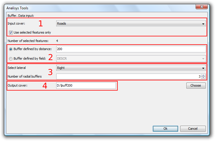
Lateral buffer
The form is divided into the following parts:
- Selection of elements for which buffers will be calculated. From the drop-down list select the vector layer on which to apply the calculation. Optionally, select the "Use selected features only" checkbox to restrict the calculation of buffers to the currently selected items in the specified layer.
- Definition of the characteristics of the buffers to be calculated. You can either enter the buffer distance (in the first text entry box) or specify a field in the input layer which contains the buffer distances to apply. This second option allows you to apply different buffer sizes for different vector elements (whereas the first option applies the same buffer size to all elements of the input layer).
- Selecting the number of radial buffers and the type of lateral buffer. gvSIG's "lateral buffer" geoprocess allows you to generate various buffers equidistant from the original geometry (for example, if the buffer distance is set at 200 metres and two radial buffers are specified, the second buffer covers the distance of 200 to 400 metres from the geometry. Currently, for reasons of efficiency, the number of concentric radial buffers that can be generated is limited to three. Select lateral gives you the option to create the buffer to the right or the left side of the geometry, as defined by the direction the geometry was digitised.
- Details of the result layer. The outputs from this geoprocess can only be saved as shp files. For this reason, gvSIG provides options for selecting an existing shp file to overwrite, or for specifying a new shp file and path.
Once all the information necessary to calculate the buffer has been entered and the "OK" button is clicked, the input information is checked to verify if it is correct.
If the input information is correct, a dialog with a progress bar indicating the progress of the calculation of the lateral buffers is displayed.
Trim Lines
Trim Lines
The functionality provided by this geoprocess is to cut a line into sections of equal size. To access this geoprocess click on the geoprocesses that transform data and choose "Split lines". Click on "Open geoprocess" to display the following window:
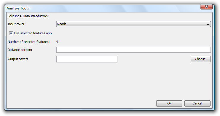
Enter the following data:
- Input cover: The Layer to be cut into into sections of equal size. You can also activate the "Use selected features only" check box to restrict the line cutting to selected lines only.
- Distance section: Enter the length of the new lines.
- Output cover: Enter the name and path of the layer for saving the changes. You can check that everything is correct by creating a field and then calculating the lengths of the new lines by means of the field calculator. Note that the last line section will not necessarily be the specified length, but will have a length less than or equal to the desired length.
Credits
gvSIG extension
Sponsored by:
Landeshauptstadt München, Referat für Gesundheit und Umwelt
Bayerstr. 28a, 80335 München
E-Mail: gube.rgu@muenchen.de
Web: http://www.muenchen.de/rgu
Developed by:
- IVER Information Technologies
C / Lérida Nº 20
46009 Valencia
Tel: 902 25 25 40 - Fax: 96 316 27 16
E-Mail: dac@iver.es
Web: http://www.iver.es/
- CSGIS Jose Canalejo & Ruth Schönbuchner GbR
Innere Wiener Str. 32
D - 81667 München
Email: info@csgis.de
Web: http://csgis.de/
Project sheet
Project identifier:
Project identifier with 14 characters or less, it will only have upper or lower case, numbers and dashes (_ and -)
gvsig-geoproces
Project title :
Descriptive name for the project, with 40 characters or less.
LateralBufferAndSplitLineGeoprocess
Project short description
Brief description of the project with two or three paragraphs, between 100 and 2000 characters.
It consists of a plugin with new features demanded by the Munich's council to be developed on the program gvSIG (Geographic Information System (GIS)). These features are a compendium of what is needed for certain tasks the council.
These features are:
- Geoprocesses: Add lateral buffer and add split lines.
It consist to add a new lateral buffer geoprocess, this functionality create a new buffer in the selected side with the user.
And a new split line geoprocess, this functionality split the layer's lines in segments who specify the user.
License
GNU General Public License (GPL)
Sources
URL to access the source code SVN/CVS repository
Version 0.1.0
Checklist
Check list
| Deliverable | Requirements | Comments | Status |
|---|---|---|---|
| Project sheet | Rejected | ||
| Project identifier | ---> Done | ||
| Project title | ---> Done | ||
| Short description project | ---> Done | ||
| License | ---> Done | ||
| Contacts | Done | ||
| Main contact | ---> Done | ||
| Technical contact | ---> Done | ||
| Sources | Done | ||
| Public access to the source code | ---> Done | ||
| Strings in english | ---> Done | ||
| Dependency report (description3 , template3) | Done | ||
| Project dependences | ---> Done | ||
| Dependency Tree | ---> Done | ||
| Licenses | ---> Done | ||
| Dependency Repository Locations | ---> Done | ||
| README, README_es (description1, template1 ) | Done | ||
| README.txt in source code | ---> Done | ||
| Introduction | ---> Done | ||
| Version information | ---> Done | ||
| Build instructions | ---> Done | ||
| Packaging instructions | ---> Done | ||
| Internazionalization notes | ---> Done | ||
| Public access to package tools | ---> Done | ||
| User manual | Not recieved | ||
| Introduction | ---> Not recieved | ||
| Requeriments | ---> Not recieved | ||
| Installation | ---> Not recieved | ||
| Instructions for use | ---> Done | ||
| Credits | ---> Not recieved | ||
| Test plan | Not recieved | ||
| Test plan | ---> Not recieved | ||
| Analysis documentation (description2) | Done | ||
| Introduction | ---> Done | ||
| Context | ---> Done | ||
| Developers overwiew | ---> Done | ||
| Components overview | ---> Done |
Status values:
- Done
- Being reviewed
- Rejected
- Not recieved
Project dependencies
Project Dependencies
Compile
The following is a list of compile dependencies for this project. These dependencies are required to compile and run the application:
| Artifact | Version | Type |
|---|---|---|
| gdbms-0.8-SNAPSHOT.jar | 1.10.0 | jar |
| com.iver.cit.gvsig.geoprocess.jar | 1.10.0 | jar |
| jts-1.9.jar | 1.9 | jar |
| andami.jar | 1.10.0 | jar |
| com.iver.cit.gvsig.jar | 1.10.0 | jar |
| org.gvsig.exception.jar | 1.10.0 | jar |
| fmap.jar | 1.10.0 | jar |
| iver-utiles.jar | 1.10.0 | jar |
| org.gvsig.ui.jar | 1.10.0 | jar |
| org.gvsig.exception.jar | 1.10.0 | jar |
| org.cresques.cts.jar | 1.10.0 | jar |
Runtime
The following is a list of runtime dependencies for this project. These dependencies are required to run the application:
| Artifact | Version | Type |
|---|---|---|
| gdbms-0.8-SNAPSHOT.jar | 1.10.0 | jar |
| com.iver.cit.gvsig.geoprocess.jar | 1.10.0 | jar |
| jts-1.9.jar | 1.9 | jar |
| andami.jar | 1.10.0 | jar |
| com.iver.cit.gvsig.jar | 1.10.0 | jar |
| org.gvsig.exception.jar | 1.10.0 | jar |
| fmap.jar | 1.10.0 | jar |
| iver-utiles.jar | 1.10.0 | jar |
| org.gvsig.ui.jar | 1.10.0 | jar |
| org.gvsig.exception.jar | 1.10.0 | jar |
| org.cresques.cts.jar | 1.10.0 | jar |
Test
The following is a list of test dependencies for this project. These dependencies are only required to compile and run unit tests for the application:
| Artifact | Version | Type |
|---|---|---|
| gdbms-0.8-SNAPSHOT.jar | 1.10.0 | jar |
| com.iver.cit.gvsig.geoprocess.jar | 1.10.0 | jar |
| jts-1.9.jar | 1.9 | jar |
| andami.jar | 1.10.0 | jar |
| com.iver.cit.gvsig.jar | 1.10.0 | jar |
| org.gvsig.exception.jar | 1.10.0 | jar |
| fmap.jar | 1.10.0 | jar |
| iver-utiles.jar | 1.10.0 | jar |
| org.gvsig.ui.jar | 1.10.0 | jar |
| org.gvsig.exception.jar | 1.10.0 | jar |
| org.cresques.cts.jar | 1.10.0 | jar |
Dependency Tree
- jts-1.9.jar
Licenses
- GNU Lesser General Public Licence (LGPL):
- jts-1.9.jar
Dependency Repository Locations
| Artifact | Location |
|---|---|
| jts-1.9.jar | http://sourceforge.net/projects/jts-topo-suite/files/ |
Developers documentation
Introduction
We try to incorporate new functionality demanded by the Department of Health and Environment of the City of Munich.
This specific functionality, intended to support two new geoprocessing that extend from the same classes as the existing geoprocessing and their functionality will be on the one hand side to create a buffer on the other hand, split lines consisting of a layer from lines, and a distance, these lines cut in sections of this distance.
This extension of gvSIG is an independent and uses the core to perform its functionality without changing the core code, but they develop and improve it.
Context
To establish an overview of situations where this component from the rest of gvSIG, we need to incorporate two new geoprocessing buffer to generate a lateral and on the other hand, can be generated from a line layer, and a distance, these lines cut in sections of this distance.
This plugin will add a few classes and also a single extension of gvSIG which recorded two new geoprocessing, so the code of plugin stays in the background image within gvSIG, without going into FMAP.
Add geoprocess laretal Buffer.
- Add a new lateral Buffer geoprocess extend some functionalities of geoprocess Buffer.

Add geoprocess split lines.
- Add the new geoprocessing Split lines that extend from the abstract geoprocesses which extend all the geoprocessing.

Developers overview
Es una nueva funcionalidad que lo que pretende es añadir dos nuevos geoprocesos a los ya existentes, por un lado el buffer lateral y por otro el split lines.
- Añadir geoproceso Buffer laretal.
Trata de un nuevo geoproceso, basado en el de buffer, y que se diferencia en que en vez de hacer un buffer alrededor de toda la geometría lo hace únicamente a un lado, pudiendo el usuario especifcar en que lado, izquierda o derecha.
Este nuevo geoproceso trabaja únicamente sobre capas de tipo línea.
- LateralBufferVisitor: Clase abstracta que extiende de BufferVisitor que implementa los métodos no especificos del tipo de buffer lateral.
- AttributeLateralBufferVisitor: Implementación que extiende de LateralBufferVisitor y que aporta los métodos relativos a obtener la medida de distancia de una campo en concreto.
- ConstantDistanceLateralBufferVisitor: Implementación que extiende de LateralBufferVisitor y que aporta los cálculos para trabajar con la distancia en forma de constante.
- LateralBufferPanelIF: Interfaz que extiende de BufferPanelIF.
- GeoprocessingLateralBufferPanel2: Implementa la interfaz LateralBufferPanelIF y es el panel que el usuario rellenará para trabajar con el buffer lateral.
- LateralBufferGeoprocess: Es el encargado de poner en segundo plano el proceso de crear el buffer lateral de toda la capa o de los elementos seleccionados.
- LateralBufferGeoprocessControler: El controlador del proceso de creación del buffer lateral.
- LateralBufferGeoprocessPlugin: Es la clase encargada de gestionar el controlador así como la estructura en el árbol de geoprocesos del proceso de buffer lateral.
- RegisterGeoprocessExtension: Extensión encargada de registrar el LaterlaBufferGeoprocessPlugin.

- Añadir geoproceso split líneas.
Trata de un nuevo geoproceso y consiste en a partir de uan capa de líneas, y una distancia, cortar dichas líneas en tramos de dicha distancia.
- FeatureSplitLines: Clase encargada de gestionar el proceso de creación de los split a partir de las líneas.
- SplitLinesPanelIF: Interfaz que especifica los métodos que tendrá la interfaz gráfica.
- GeoprocessingSplitLinesPanel2: Implementa la interfaz SplitLinesPanelIF y es el panel que el usuario rellenará para trabajar con el split de las líneas.
- SplitLinesGeoprocess: Es el encargado de poner en segundo plano el proceso de crear el split de líneas de toda la capa o de los elementos seleccionados.
- SplitLinesrGeoprocessControler: El controlador del proceso de creación del split de las líneas.
- SplitLinesGeoprocessPlugin: Es la clase encargada de gestionar el controlador así como la estructura en el árbol de geoprocesos del proceso de split líneas.
- RegisterGeoprocessExtension: Extensión encargada de registrar el LaterlaBufferGeoprocessPlugin.

Componets overview
Cached time 11/21/13 08:21:29 


