Document Actions
Parameters of the remote resource
Just as for servers and services, we can configure basic and advanced parameters. In this case, on the left of the wizard will have a tree that will allow us to navigate the remote resources and to the right the information of those parameters.
Consider first the basic parameters shared by all remote resources implemented in this version.
- Name: Unique name that identifies the remote resource. GvSIG automatically generates the name and the service client uses it in a transparently way to the user.
Note
In Mapserver, the resource name is the name of the layer defined in the gvSIG view, therefore, the user can control this parameter. In contrast, in Geoserver, the resource name is automatically generated and can not be changed.
- Title: Set of words that allows the user to identify the remote resource.
- Summary: Description of the remote resource.
Moreover and as shown in the figure below we have two basic operations for adding and removing remote resources to the publication.
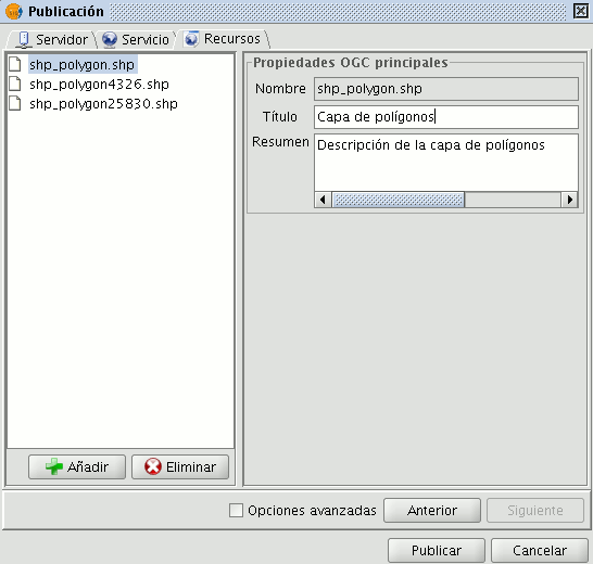
Addition/deletion of resources and their metadata.
The advanced settings that are available in this release are detailed below.
Mapserver WMS
- Searchable: Enables the operation GetFeatureInfo to query the alphanumeric values of the layer.
- Image Mosaic: Allows for the creation of a layer that is a mosaic of images (TILEINDEX of Mapserver). Currently only the shapefiles containing an attribute name location and containing the path to raster may be mosaics. In the case that the path is relative to the raster file, you must specify the base directory in the Mapserver advanced options. A tool to easily generate these shapefiles is gdaltindex (tool GDAL / OGR).
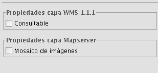
Advanced Parameters for the Mapserver WMS
Geoserver WFS
- Namespace: the namespace prefix of GML generated by Geoserver. This parameter is generated automatically by gvSIG and for shapefiles is set to the directory containing the file, for PostGIS is set to the name of the database.
- Cache: Modify the parameter Cache-Control: max-age = XX in the HTTP header in order to make caching requests.
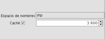
Advanced Parameters for the Geoserver WFS


