gvSIG-Desktop 1.12. Manual de usuario
Lateral Buffer
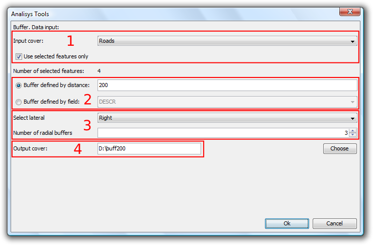
Select "lateral buffer" from the proximity geoprocesses and click "Open Geoprocess" to show the form related to this geoprocess:

Lateral buffer
The form is divided into the following parts:
- Selection of elements for which buffers will be calculated. From the drop-down list select the vector layer on which to apply the calculation. Optionally, select the "Use selected features only" checkbox to restrict the calculation of buffers to the currently selected items in the specified layer.
- Definition of the characteristics of the buffers to be calculated. You can either enter the buffer distance (in the first text entry box) or specify a field in the input layer which contains the buffer distances to apply. This second option allows you to apply different buffer sizes for different vector elements (whereas the first option applies the same buffer size to all elements of the input layer).
- Selecting the number of radial buffers and the type of lateral buffer. gvSIG's "lateral buffer" geoprocess allows you to generate various buffers equidistant from the original geometry (for example, if the buffer distance is set at 200 metres and two radial buffers are specified, the second buffer covers the distance of 200 to 400 metres from the geometry. Currently, for reasons of efficiency, the number of concentric radial buffers that can be generated is limited to three. Select lateral gives you the option to create the buffer to the right or the left side of the geometry, as defined by the direction the geometry was digitised.
- Details of the result layer. The outputs from this geoprocess can only be saved as shp files. For this reason, gvSIG provides options for selecting an existing shp file to overwrite, or for specifying a new shp file and path.
Once all the information necessary to calculate the buffer has been entered and the "OK" button is clicked, the input information is checked to verify if it is correct.
If the input information is correct, a dialog with a progress bar indicating the progress of the calculation of the lateral buffers is displayed.


